anden.at

Discover the Andes

Excursion guide Movies Photos Presentations

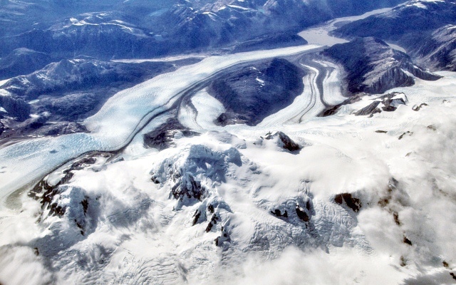
Cerro Arenales and Glaciar Colonia

by Martin Mergili

Southern Patagonian Andes Map
General information

Cerro Arenales is a 3437 m high stratovolcano, the summit of which rises above the Northern Patagonian Ice Field. Due to the remoteness and limited acessibility, and the ice cover, the mountain was recognized as a volcano only in 1963. The discovery of a minor tephra deposit from satellite imagery in 1979 falsified the earlier assumption that the volcano would be extinct. Various outlet glaciers reach down into the valleys on the eastern and western sides of the ice field. Some - among them Glaciar Colonia - calve into lakes. Cerro Arenales and its surroundings are hard to reach, and therefore best observed from the air. On flights between Puerto Montt and Punta Arenas, it is recommended to choose a seat on the eastern side in order to have the best chance of catching a glimpse of the scene.

Photo

Aerial views of Cerro Arenales

1 of 2

By clicking on the arrows or in the image, you can view the scene from a slightly different perspective.

Aerial image of Cerro Arenales, view in eastern direction. The large glacier in the upper left portion of the photo is Glaciar Colonia. It impounds two lakes, one of which produces outburst floods from time to time.

img
Graphics

3D view of the Northern Patagonian Ice Field around Cerro Arenales

This 3D view helps you to change between various perspectives. Use the left mouse key for rotating the view, the mouse wheel for zooming, and the right mouse key for panning.

The eastern margin of the ice field is shaped by a system of outlet glaciers and the related glacial lakes. The evolution of this type of landscape is explained in detail in the system description of the Southern Patagonian Andes.

This scene was generated with the QGIS plugin Qgis2threejs and uses the following libraries: three.js http://threejs.org/ (LICENSE) and Proj4js http://trac.osgeo.org/proj4js/ (LICENSE). Background: Bing Aerial.

Task

Cerro Arenales as a volcano

Cerro Arenales is a heavily glacierized volcano. Even though, up to now, only one minor eruption has been recorded, it cannot be completely ruled out that a larger eruption could occur at some point of time in the future.

  1. What happens with the ice if an ice-clad volcano erupts?
  2. Inhowfar can such a situation increase the risk for the population in the surrounding areas?
  3. Search the web for pieces of information on the consequences of the eruption of ice-clad volcanoes in the past.
Show solution
  1. Due to the high temperature during an eruption, a large amount of ice can melt within a short period of time.
  2. The water released through the rapid melting of the glacier can move down along the steep slopes and valleys of the volcano. Thereby it can erode large quantities of loose debris, resulting in volcanic mud flows or mud avalanches (lahars). They can travel for several tens of kilometres and are therefore hazardous even in the case when the direct surroundings of the volcano are uninhabited.
  3. Such scenarios become real from time to time - two examples are mentioned here: the Hudson volcano, located approx. 120 km north of Cerro Arenales, erupted in the years 1971 and 1991. Both events resulted in destructive lahar flows, even leading to fatalities in 1971. A lahar induced by the eruption the Nevado del Ruiz volcano in Colombia in 1985 was even more dramatic: the town of Armero, at a distance of almost 50 km from the place of eruption, was destroyed, and more than 20,000 people lost their lives.
References and links

Cerro Arenales in the Global Volcanism Program of the Smithsonian Institution [Access source]

Wikipedia article on Cerro Arenales [Access source]

Wikipedia article on Glaciar Colonia [Access source]