anden.at
Discover the Andes


Pucará de Quitor
by Thomas Lindinger, Martin Mergili, and Simon Schmidthaler


anden.at
Discover the Andes
by Thomas Lindinger, Martin Mergili, and Simon Schmidthaler

Pachacutec, who has just arrived from Arequipa, has climbed up to the viewpoint near the Pucará de Quitor. He looks down to the bizarre formations of the Cordillera de la Sal, to San Pedro and the Salar de Atacama all the way to the volcano Licancabur. He dreams of the great times of the Inca. The army of the Inca was organized better thn any other army in South America in those ancient times. It was larger, could move more rapidly, and therefore won almost every battle. The Inca soldiers usually wore quilted tunics, helmets made of wood, and shields of hardened leather or wood. In close combats they used clubs, spears, or two-handed swords of hard chonta wood. Laughing tourists take Pachacutec's mind back to present. He knows that quite soon he will have to proceed southwards to Santiago de Chile.
By clicking on the warrior symbol you can obtain more information on the road network of the Inca. But what about the former fortress of Pucará de Quitor you can see in the title image? Was it built by the Inca? Try to find out the answer!

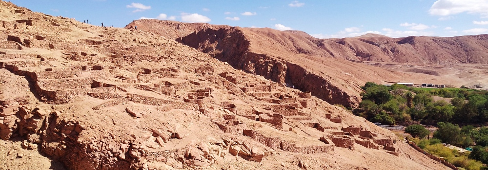
The Pucará de Quitor was neither built nor conquered by the Inca. In contrast, it was a residential and refugial site of another well-fortified people: the Atacameños, whose descendants still live in this area today. The fortress served to defend the oasis against hostile tribes. It was built in way to allow the storage of stock over longer time spans to withstand sieges. In the middle of the 16th Century, the Pucará de Quitor was invaded and destroyed by the Spanish conquistadors. Today it is accessible to visitors and offers excellent views of the striking geological features of the Cordillera de la Sal, of San Pedro de Atacama, and across the northern part of the Salar de Atacama all the way to the Altiplano with its stratovolcanoes such as the Licancabur.
Enjoy a similar view from the Pucará de Quitor as Pachacutec by clicking into the title photo.

The perfect example of a horizontal fold
This photograph - shot from the main viewpoint at the Pucará de Quitor - shows a classic example of a horizontal fold: the sedimentary rocks, originally deposited as horizontal layers, vere tilted and folded due to compressive forces. The effects of erosion differ between harder and softer rocks: basset edges of the harder layers are etched into relief so that the original layering can be well recognized.
You are invited to visit the contribution on the Cordillera de la Sal to learn more about its rocks and its evolution.


The play of clouds above the Río San Pedro
Click on the arrow to start the time lapse video.
This time lapse video shows the valley of the Río San Pedro during the weather phenomenon Invierno Boliviano, which is characterized by moisture-laden air masses crossing the Andes and proceeding all the way to the Salar de Atacama. The consequence are clouds, heavy rainfall, and even hail, as you can see in the contribution on the Laguna Tebinquinche. Even though the morning weather is fine here, thunderstorms in the evening before resulted in the mobilization of loose material lending the red colour to the river.
Time lapse video: Claudia Blauensteiner

Métraux, A. (2001): Reich der Inka. Stuttgart
Wood, T. (1996): Die Inkas. Erlangen
Wikipedia article on the Pucará de Quitor [Access source]