anden.at
Discover the Andes


The volcanoes Osorno and Calbuco
by Martin Mergili


anden.at
Discover the Andes
by Martin Mergili

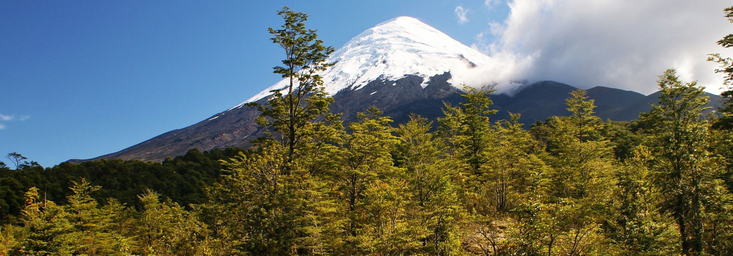
The volcano Osorno, located between the Lago Llanquihue and the Lago Todos Los Santos, represents a good example of a regularly shaped stratovolcano. The 2652 m high mountain, whose summit is covered by an ice cap, last erupted in the 19th Century. Its slopes are partly used for skiing, whereas other parts are protected through the Vicente Perez Rosales National Park. The volcano (except for its summit area) and its surroundings are easily accessible, and its slopes offer comprehensive views across the Lago Llanquihue all the way to another stratovolcano, which has attracted more attention in the early 21st Century than its larger brother: the Calbuco.
Click into the title image to climb the slopes of the Osorno, or to view this volcano from some distance.

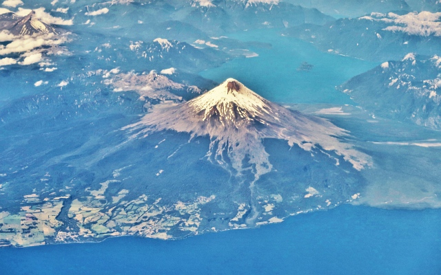
Volcán Osorno and its surroundings


Click on the arrows or into the photo to explore the slopes of the volcano.
Aerial image of the Volcán Osorno, view in eastern direction: Lago Llanquihue appears in the foreground, whereas the Lago Todos Los Santos can be seen on the right side behind the volcano. The treeline at the western slopes is located at approx. 1200-1300 m asl., whereas forest growth cannot keep pace with slope dynamics on the southern side, so that the southern beech forest gives way to areas largely bare of vegetation already at approx. 700 m asl.

The volcano Calbuco: a twitchy guy
Travel in time by clicking on the arrows or into the satellite scene.
This series of false colour satellite images (vegetation is shown in red colour) shows the volcano Calbuco at three points in time in the years 2015 and 2016.
Describe the individual scenes and consider particularly the differences between the first and the third scene. With the knowledge about the Osorno volcano and the volcano Puyehue-Cordón Caulle, it will be easy for you to answer the following questions:
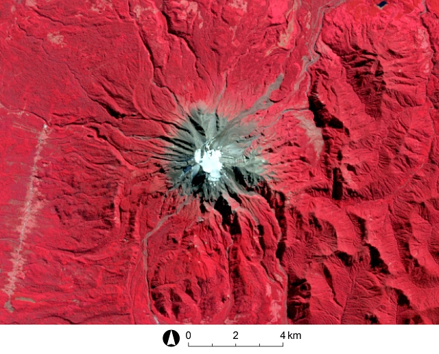
Imagery source: Landsat | Band combinations 5-4-3 of Landsat 8
The first scene is obviously dominated by dense forest, which is only interrupted by the volcano in the centre. The summit area of the volcano appears to be covered by an ice cap. From here, various valleys cut through the slopes of the volcano in a radial pattern. The traces of at least one former lahar flow can be seen on the northern side.
Most of the second scene is obscured by clouds or aerosols. A thick cloud rises from the summit area of the volcano, moving in southern direction. Obviously, this scene shows the volcano in the stage of an explosive eruption, so that huge amounts of pyroclastic material (ash, lapilli, blocks, and volcanic bombs) are ejected into the atmosphere. The haze covering almost the entire scene is most likely related to the eruption.
In the third scene - recorded in the summer of the following year - the view is clear again. However, the ice cap of the volcano has disappeared, and the area with no or little vegetation has grown in comparison to the first scene and has a diffuse margin - this concerns particularly the northeastern slopes of the volcano and indicates the deposition of pyroclastic material. Some valleys which had still been covered with vegetation in the first scene are now vegetation-free. This indicates the occurrence of lahar flows. All these observations are most likely related to the eruption shown in the second scene.
The eruption of the Volcán Calbuco - which is seen here in February 2016 from the slopes of the Volcán Osorno from northeastern direction - started on 22 April 2015 and occurred in three stages. Pyroclastic material was ejected up to 15 km high into the atmosphere and deposited in the surroundings with a thickness up to half a metre. There were also lava flows. Meltwater from the ice cap led to lahar flows and flooding. The eruption resulted in evacuations around the volcano and flight cancellations across the border in Argentina.
Furthermore, the eruption of the Calbuco had a direct consequence for the size of the ozone hole above Antarctica in 2015, which was extraordinarily large. This relationship can be explained by chemical reactions of natural halogene compounds emitted into the atmosphere during the eruption.

The eruption of the Volcán Calbuco in April 2015 has been documented by many photographs and videos. This video shows the eruption during night: https://www.youtube.com/watch?v=oQPAawaY2D8. A compilation of various scenes you can find here: https://www.youtube.com/watch?v=zlfDGe4hlAs or here: https://vimeo.com/130622230.

Castruccio, A., Clavero, J. & Rivera, A. (2010): Comparative study of lahars generated by the 1961 and 1971 eruptions of Calbuco and Villarrica volcanoes, Southern Andes of Chile. Journal of Volcanology and Geothermal Research 190(3-4): 297-311 [Access source]
Castruccio, A., Clavero, J., Segura, A., Samaniego, P., Roche, O., Le Pennec, J.L. & Droguett, B. (2016): Eruptive parameters and dynamics of the April 2015 sub-Plinian eruptions of Calbuco volcano (southern Chile). Bulletin of Volcanology 78(9): 62 [Access source]
Ivy, D.J., Solomon, S., Kinnison, D., Mills, M.J., Schmidt, A. & Neely, R.R. (2017): The influence of the Calbuco eruption on the 2015 Antarctic ozone hole in a fully coupled chemistry-climate model. Geophysical Research Letters 44(5): 2556-2561 [Access source]
Lopez-Escobar, L., Parada, M.A., Moreno, H., Frey, F.A. & Hickey-Vargas, R.L. (1992): A contribution to the petrogenesis of Osorno and Calbuco volcanoes, Southern Andes (41° 00'-41° 30'S): comparative study. Andean Geology 19(2): 211-226 [Access source]
Romero, J.E., Morgavi, D., Arzilli, F., Daga, R., Caselli, A., Reckziegel, F., Viramonte, J., Díaz-Alvarado, J., Polacci, M., Burton, M. & Perugini, D. (2016): Eruption dynamics of the 22-23 April 2015 Calbuco Volcano (Southern Chile): Analyses of tephra fall deposits. Journal of Volcanology and Geothermal Research 317: 15-29 [Access source]
Van Eaton, A.R., Amigo, Á., Bertin, D., Mastin, L.G., Giacosa, R.E., González, J., Valderrama, O., Fontijn, K. & Behnke, S.A. (2016): Volcanic lightning and plume behavior reveal evolving hazards during the April 2015 eruption of Calbuco volcano, Chile. Geophysical Research Letters 43(7): 3563-3571 [Access source]
The volcano Calbuco in the Global Volcanism Program of the Smithsonian Institution [Access source]
The volcano Osorno in the Global Volcanism Program of the Smithsonian Institution [Access source]
Spanish-language CONAF entry on the Vicente Pérez Rosales National Park [Access source]
Wikipedia article on the volcano Calbuco [Access source]
Spanish-language Wikipedia article on the volcano Osorno [Access source]