anden.at
Discover the Andes


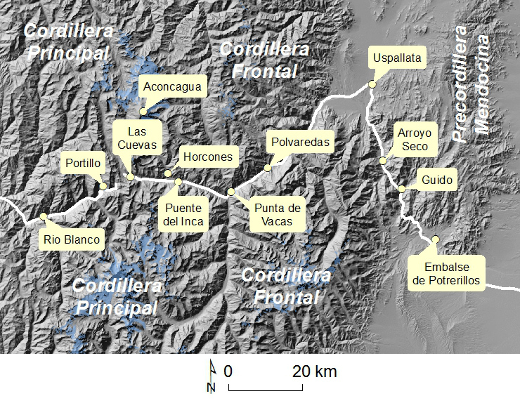
Trans-Andean Corridor Mendoza - Valparaíso
by Vanja Bajakic and Stefan Koller


West of the city of Mendoza, the Andes reach their highest elevation in the summit of Cerro Aconcagua. Directly south of Aconcagua, two major valley have been incised into the terrain of alpine type: the valley of the Río Mendoza on the Agentine side, and the Aconcagua Valley on the Chilean side, connected by a relatively low and easy-to-cross mountain pass, which has already been used by the national heroes of the early 19th Century. Still in the early 21st Century, the most important traffic link between Argentina and Chile runs along the same line: the Trans-Andean Corridor Mendoza - Valparaíso, which is part of the Corredor Bioceánico. The geomorphological diversity along this route is tremendous. However, the steep terrain also bears some landslide hazards, affecting traffic from time to time.
Click on the red symbols to visit the corresponding points of interest.


The Andes west of Mendoza in 3D
You can view this scene from various perspectives. Use the left mouse key to rotate, the mouse wheel to zoom, and the right mouse key to drag the scene.
In principle, the Andes consist of three parallel ranges at this latitude: the Precordillera Mendocina in the east is the geologically oldest among all of them. It is separated from the more than 6000 m high Cordillera Frontal by the Uspallata Valley, a tectonic graben. West of the Cordillera Frontal, Cerro Aconcagua is part of the Cordillera Principal. This range drops steeply towards west, resulting in a clearly asymmetric profile of the Andes.
This scene was generated with the QGIS plugin Qgis2threejs and uses the following libraries: three.js http://threejs.org/ (LICENSE) and Proj4js http://trac.osgeo.org/proj4js/ (LICENSE). Background: Bing Aerial.

What does this photograph want to tell us?
This image was taken close to Las Cuevas at more than 3100 m asl.
First, describe the photograph, and then find a suitable story for its content!
Show solution

Natural hazards along the Trans-Andean Corridor
First, visit the individual points of interest along the Trans-Andean Corridor, and learn which types of landslide processes are or were most important in which places. Then, assign the individual clips to the corresponding points in the map.
Grab the animation at the upper left symbol, and drag the symbol into the corresponding circle in the map.


Terrain derived from SRTM V4 data. Glaciers: subset of the GLIMS database. Points and road mapped from OpenStreetMap.

Abele, G. (1984). Derrumbes de montaña y morrenas en los Andes chilenos. Revista de Geografía Norte Grande 11: 17-30
Caviedes, C. (1972). Geomorfología del Cuarternario del valle del Aconcagua, Chile Central. Freiburger Geographische Hefte 11: 153 Seiten
Hauser, A. (2000). Flujos detríticos en segmento del Camino Internacional a Argentina, sector Juncal - Paso Los Libertadores: Causas, efectos, medidas de control. Bericht des Servicio Nacional de Geología y Minería, Subdirección Nacional de Geología, Santiago de Chile. 14 Seiten
Moreiras, S.M. (2004): Landslide incidence zonation in the Rio Mendoza valley, Mendoza province, Argentina. Earth Surface Processes and Landforms 29(2): 255-266 [Access source]
Moreiras, S.M. (2005): Landslide susceptibility zonation in the Rio Mendoza valley, Argentina. Geomorphology 66(1-4): 345-357 [Access source]
Moreiras, S.M. (2005): Climatic effect of ENSO associated with landslide occurrence in the Central Andes, Mendoza province, Argentina. Landslides 2(1): 53-59 [Access source]
Moreiras, S.M. (2006): Frequency of debris flows and rockfall along the Mendoza river valley (Central Andes), Argentina: Associated risk and future scenario. Quaternary International 158(1): 110-121 [Access source]
Moreiras, S.M., & Sepúlveda, S.A. (2015). Megalandslides in the Andes of central Chile and Argentina (32°-34° S) and potential hazards. Geological Society, London, Special Publications, 399(1), 329-344 [Access source]
Wikipedia article on the Transandine Railway [Access source]
This contribution was revised, extended, and translated from German by Martin Mergili.