anden.at
Discover the Andes


Southern Patagonian Andes
by Martin Mergili


anden.at
Discover the Andes
by Martin Mergili


The southern Andes form the backbone of Patagonia. Whereas the active stratovolcanoes such as Lautaro or Cerro Arenales are largely covered by ice, the granite summits of the Torres del Paine, Cerro Torre, or Monte Fitz Roy (title image) dominate the landscapes through their pronounced shapes. You can find and elaborate more information on the geological history of those mountains in the article on the Cordillera del Paine, forming part of the Andes of southern Patagonia. The present article, in contrast, focuses on the climate, glaciers, and vegetation prevailing in this area.
Click on the title image to watch the sunrise from the Mirador del los Cóndores in El Chaltén.

Glaciers and landforms of the southern Patagonian Andes


The Pleistocenic, but also the contemporary glaciers play an important role for the landscape evolution of the southern Patagonian Andes. Like everywhere on the globe, the extent of the glaciers was much larger at some point in former times, compared to today.
However, has the retreat of glaciers proceeded to an equal degree in all glacierized areas worldwide? And if not, how can the differences be explained? Compare the eastern side of the southern Patagonian Andes (A) with the Southern Alps of New Zealand (B) and the northern rim of the Austrian Alps (C). By clicking on the symbols A, B, and C you can switch between the 3D views of the three regions. Use the left mouse button for rotating the view, the mouse wheel for zooming, and the right mouse button for panning.
These scenes were generated with the QGIS plugin Qgis2threejs and use the following libraries: three.js http://threejs.org/ (LICENSE) and Proj4js http://trac.osgeo.org/proj4js/ (LICENSE). Background: Bing Aerial.

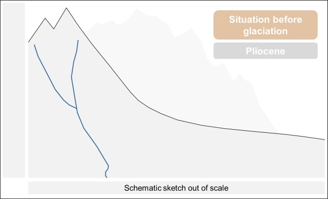
West-east profile representing the climate and glaciers of southern Patagonia


By clicking on the arrows or into the graphics you can switch between various stages. Clicking the red symbols leads you to the individual points of interest.
The Patagonian Andes form an important climatic divide stretching in north-south direction.
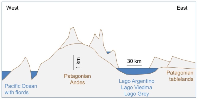

This model represents a distorted schematic sketch out of scale, not claiming to be complete or correct. Its purpose is to convey some general understanding of the system under investigation.
Influence of the southern Patagonian Andes on the distribution of the vegetation zones

The north-south stretching Andes do not only influence the climate, but also the vegetation. Use your knowlwdge obtained in the task about climate and glaciers to assign the major types of vegetation to their correct locations.
Here you can see a broad-leaf forest, which is dominated by the evergreen southern beech species Nothofagus betuloides.
Grab the photo by holding the symbol near the upper left corner, and drag the symbol into the corresponding circle in the map.


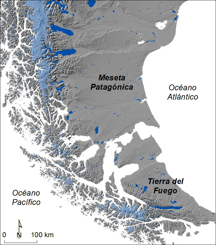
Terrain derived from SRTM V4 data. Glaciers extracted from the GLIMS database. Lakes: DIVA-GIS.

Hofmann, R. (2007): Physisch-geographische Aspekte der südlichen Anden mit besonderer Berücksichtigung der Eisfelder und deren Umfeld. RWTH Aachen [Access source]